| Weather Data | |||
|---|---|---|---|
| LAST READING AT TIME: 17:30 DATE: July 27 2024, time of next update: 17:35 | |||
| Current Weather | Dry | Current Temperature | 33.4°C (92.2°F) (Heat Index 47.3°C ), Apparent temp 38.8°C , Apparent temp solar 42.3°C |
| Maximum Temperature (since midnight) | 36.6°C at: 13:46 | Minimum Temperature (since midnight) | 27.1°C at: 00:00 |
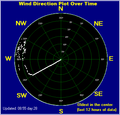
| Average windspeed (ten minute) | 1.0 m/s | Wind Direction (ten minute) | SW (217°) |
| Heat Index | 47.3°C | Maximum Gust (last hour) | 4.5 m/s at: 16:43 |
| Maximum Gust (since midnight) | 4.6 m/s at: 13:24 | Maximum 1 minute average (since midnight) | 3.7 m/s at: 14:02 |
| Rainfall (last hour) | 0.0 mm | Rainfall (since midnight) | 0.0 mm (0.00 in.)--- |
| Rainfall This month | 72.4 mm (2.85 in.) | Rainfall To date this year | 707.8 mm (27.87 in.) |
| Maximum rain per minute (last hour) | 0.0 mm/min | Maximum rain per hour (last 6 hours) | 0.0 mm/hour |
| Yesterdays rainfall | 0.6 mm | DewPoint | 28.4°C (Wet Bulb :29.7°C ) |
| Humidity | 75 %, Humidex 49.9°C | Barometer corrected to msl | 1014.6 hPa |
| Pressure change | +0.4 hPa (last hour) | Trend (last hour) | STEADY |
| Pressure change (last 12 hours) | -2.2 hPa | Pressure change (last 6 hours) | -1.4 hPa |
| Current solar | 16 W/m² | Current UV | 0.0 |
| Maximum solar (since midnight) | 891 W/m² | Maximum UV (since midnight) | 9.5 |
| Current 05:01 hours of sunshine today, current sky: Overcast and gloomy | |||
| Sunshine hours for the year: | 870:16 hrs | Sunshine hours for the month: | 116:32 hrs |
| Current evapotranspiration rate 7.2 mm per day. Yesterday's reading 5.6 | |||
Use the RELOAD facility on your browser to retrieve the latest data.